PLN
PLN BRL
BRL CZK
CZK EUR
EUR EUR
EUR EUR
EUR EUR
EUR GBP
GBP RUB
RUB SEK
SEK USD
USD

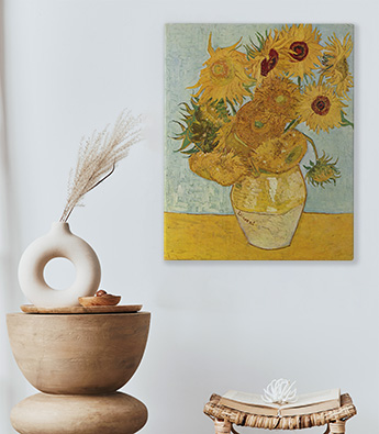


Poster
Les posters standards myloview sont imprimés sur un papier poster de haute qualité avec une finition satinée. Les posters sont réalisés en utilisant la technologie avancée HP Latex garantissant des couleurs profondes et vives. Une fois déballé, le poster est prêt à être installé sur le mur. Il est également disponible sous verre ou avec un élégant cadre extérieur.
Grammage du papier poster : 180g/m2
Suppléments disponibles : vous pouvez choisir un poster encadré (cadres aluminium disponibles en noir et argent) ou sous-verre
Nettoyage : le matériau peut être essuyé avec un chiffon humide.

Poster encadré
Les posters standards myloview sont imprimés sur un papier poster de haute qualité avec une finition satinée. Les posters sont réalisés en utilisant la technologie avancée HP Latex garantissant des couleurs profondes et vives. Une fois déballé, le poster est prêt à être installé sur le mur.
Le poster est livré avec un cadre en aluminium disponible en noir ou argent.
Grammage du papier poster : 180g/m2
Inclus : cadre aluminium noir ou argent
Nettoyage: le matériau peut être essuyé avec un chiffon humide

Poster sous-verre
Les posters standards myloview sont imprimés sur un papier poster de haute qualité avec une finition satinée. Les posters sont réalisés en utilisant la technologie avancée HP Latex garantissant des couleurs profondes et vives. Une fois déballé, le poster est prêt à être installé sur le mur.
Le poster est livré avec un cadre sous-verre.
Grammage du papier poster : 180g/m2
Inclus : cadre sous-verre
Nettoyage : le matériau peut être essuyé avec un chiffon humide